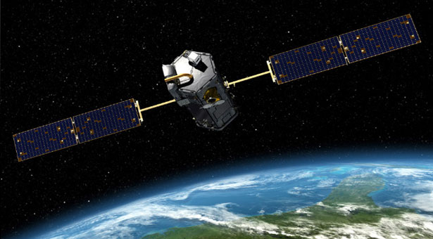
June 26, 2014 – It will cost $465 million U.S. but the Orbiting Carbon Observatory-2 (OCO-2) will be the first satellite of its type focused solely on observing CO2 levels on Earth. The launch date is July 1st. This is OCO-2 and not just OCO because in 2009 a first attempt to launch an orbiting CO2 monitoring satellite failed.
Onboard OCO-2 are three high-resolution spectrometers to measure atmospheric CO2. Why three? To measure Nadir Mode, Glint Mode and Target Mode.
Nadir Mode views the ground directly beneath the spacecraft. Glint Mode tracks locations where sunlight directly reflects off the Earth’s surface, particularly the Ocean. And Target Mode looks at specified surface targets each time the satellite passes over. The satellite will provide a detailed picture of emissions by scanning 2.59 square kilometers (one square mile) at a time.
Measuring CO2 is in fact measuring how the plant and animal life on our planet breathe as well as measuring our human activity contributions. The Ocean, forests and plants of the Earth absorb about 50% of the 40 billion tons of greenhouse gases added every year through burning fossil fuels, and human industrial and domestic activities. Today, because of the enormous amount we pump into the atmosphere, it takes 1.5 years to absorb just annual CO2 contributions. This is the reason CO2 levels continue to rise.
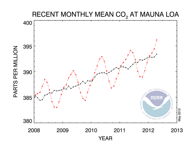
But annually we see a rise and fall to CO2 levels. That’s caused by seasonal changes which impact how CO2 gets absorbed. When winter in the Northern Hemisphere, less gets captured on land and sea, on land because deciduous trees enter dormancy and even the evergreen-dominated boreal forest is less capable of absorbing CO2 at this time of year. Add to this colder water and sea ice in the Oceans and we see as a result higher atmospheric CO2 levels.
Meanwhile the Southern Hemisphere, mostly Ocean, becomes the primary carbon sink during the southern summer. But with less forest mass, the dip in CO2 is not as pronounced as it is when summer returns to the Northern Hemisphere. Hence atmospheric readings of CO2 cycle up and down over the year as seen in the red tracings from data collected at Hawaii’s Mauna Loa site. And because the bulk of the continental land masses lie north of the equator, CO2 expresses its highest levels when winter is in the north.
So if we already know this why do we need OCO-2? The justification is this. The satellite will help identify carbon sinks. It will also give us precise readings of human and natural CO2 emissions across the entire planet. This will give scientists the means to make more accurate projections about climate change.
OCO-2 data will be compared to Japan’s Greenhouse Gases Observing Satellite (GOSAT) which is monitoring methane and CO2. And it will add to the data from ground-based observations currently being conducted by the U.S. National Oceanic and Atmospheric Administration which has been measuring atmospheric CO2 since the 1950s.
The OCO-2 mission is budgeted to last two years. Considering the importance of the data it provides we can only hope that it will remain funded well beyond that expiry date.
Related articles across the web

Related Posts
 Moon News: A Robot Excavator, Water on the Moon, and Likely Changes to the Artemis Program
 NASA, Artemis, and Mars Timelines – Part 2: Addressing Remaining Challenges
 Why Petrochemical Dependency Is Making Our Houses Burn Down
 Does Artificial Intelligence Have A Role To Play In Social Media Marketing’s Future?
 AI Developers Call Their Inventions “AI Workers” – They Are Not
 From Trash to Treasure: Revolutionizing Waste Management
  Donald Trump Threats Go Beyond Settling Economic Scores – It’s Personal for Canadians
 Invisibility Cloaking Is Closer To Reality Than Science Fiction And Fantasy
I am not persuaded that present atmospheric carbon levels are too high. But I readily concede there is some hypothetical, but as yet uncertain, level that would be too high. It might be possible that ever increasing populations burning ever increasing amounts of fossil fuels would soon exceed the “too high” level. We don’t have a credible method of determining the optimum level. Just to be safe, it would probably be a good policy to arrest the atmospheric carbon buildup.
The $465 million NASA satellite money would be much better spent trying in vain to convince mankind to abandon its age-old practice of sacrificing long-term principles to satisfy short-term desires. All we need to know about atmospheric CO2 levels is presently found in the excellent data set provided by the Mauna Loa CO2 lab. The conspicuous saw-tooth seasonal pattern proves conclusively that CO2 produced anywhere on earth soon translates to CO2 everywhere on earth. Any data the new CO2 satellite might produce will have zero positive effect on arresting or reversing increasing CO2 levels.
Look at the data/graphs of US coal production and compare them to US coal combustion. Over the last couple of decades US power plants have reduced coal combustion by about 25% (mainly by switching to NG), during which time US coal production has increased about 25%. Should we suppose giant mountains of coal are piling up at some hidden locations or that the increased production is raptured into some unknown dimension? Wouldn’t it be more plausible to suppose all the coal produced anywhere on earth is soon burned somewhere on earth?
The facts are plain. All the constantly increasing US coal production that is not burned in the US is promptly exported to be burned elsewhere; places such as India and China, where its combustion not only adds to total atmospheric carbon, but because its combustion emissions are less well regulated, also adds to environmental sulfur, mercury, cadmium, arsenic, radium, etc. The more the US EPA strangles coal combustion in the US, the more US coal will be exported. The world economy is never going to ban coal production or combustion, nor is it ever going to enforce significant sequestration of carbon emissions.
Until some magic and unexpected new form of cheap, clean, non-combustion, energy comes along, only drastic population reduction can arrest atmospheric carbon build-up. All else is just delusion, corruption, and a waste of time and money.
Hi Al, The US is exporting coal to the Developing World and Europe. So it is exporting its carbon footprint which is counterproductive to the overall global objective of reducing our carbon dependency and therefore CO2 emissions.
The NASA satellite serves many useful purposes. It will establish where current optimal carbon sinks are located. It will also give us a far more accurate picture of the distribution of CO2 in concentration across the planet. Yes we have data from Mauna Loa and from the Japanese satellite but not the granular kind of information that scientists want to better understand climate change.
And there is a good reason to want to understand it better. Why do we get lulls and lapses in atmospheric warming when we continue to see CO2 climb? This question has only been addressed hypothetically to date. We also need to understand the general cause and effect time lapse between CO2 output and rising temperatures.
And, yes, for the crazy naysayers who profess that all of this climate change is mumbo jumbo, we need more data to finally shut them up.
Arresting further carbon buildup in the atmosphere is good policy. We know one thing for sure, that the carbon we generate today will not impact tomorrow, and we don’t know when its optimal impact will actually occur. So what we are seeing today could be cause and effect from CO2 emitted in 1980, meanwhile we are emitting more greenhouse gases today than we did then.
Consider the last decade was the warmest since humans started keeping a climate scorecard, the CO2 today may have a frightening impact in several decades or even a century from now.
((Consider the last decade was the warmest since humans started keeping a climate scorecard, the CO2 today may have a frightening impact in several decades or even a century from now.))
Or it might bring more rain and a longer growing season in Siberia, Manitoba, and the U.S. Dakotas. If winters are shorter and warmer, less fuel will be burned for comfort heating in the heavily populated higher latitudes. It’s nearly impossible to rationally determine the optimum atmospheric CO2 level.
Undoubtedly, more polar latitudes will have extended growing seasons. But many of these areas in Canada and Siberia feature poor soil conditions for crops. So what we lose may not be compensated for by what we gain.
True. We just don’t know. But we do know more rain, warmer climates, longer growing seasons and les fuel for heating would be big pluses. If rain and warmth are available, we can easily improve soils. I’m guessing more rain and longer growing seasons would bring a lot more land under culyivation and reduce the amount of fossil energy needed for cultivation in lower latitudes. On the other hand, maybe a warmer climate would create dust bowls in regions that are now bread and rice baskets, Would Ukraine, China, India, produce more or less crops? It’s an interesting question to which no credible answer seems available.
Milder winters with more rain would likely shift population further north. Were it not for fossil-energy-intensive air conditioning 70-million Americans would soon relocate further north. I’m guessing it takes a lot more energy to make hot people cool than to make cold people warm. Personally, I grew acustomed to heat and humidity when I worked at Kenedy Space Center and Pratt amd Whittney’s R&D center out in the Fla. swamps some twenty miles west of Palm Beach. (The SR-71 engines and the RL-10 high SI rocket engine were developed there.) I didn’t like the hot hunid buggy tropical climate or the high electric bills, but that was where the space race action was. I’ve lived in the Houston region since 1971. My little ranchette had about 100 mature oak trees. A few years back, an uncommon 3-year prolonged drought here in the Brazos River Valley killed about 30 of them. My shallow well and its aquifer couldn’t produce enough water to irrigate them and keep them going. This year is the first time I’ve seen an ice storm, which did a lot of damage to my surviving oaks. A couple actually fell over under the weight of the ice. The only climate change I’m noticing here is drier and cooler.
[…] NASA Preparing Satellite to Monitor How the Planet Breathes https://www.21stcentech.com/nasa-preparing-satellite-monitor-planet-breathes/ […]