Unlike South America’s Andes Mountains, the Western Cordillera of North America is much more complex containing multiple mountain ranges. And North America is further differentiated by its vast central plain forming a gigantic drainage basin for the Mississippi-Missouri River system draining into the Gulf of Mexico, and a number of Canadian rivers draining into the Arctic Ocean and Hudson’s Bay. Rivers on the east coast cut through the Appalachian Mountains, an ancient range. And finally North America boasts the largest agglomeration of freshwater lakes in the world, remnants of the last Ice Age, draining into the North Atlantic through the St. Lawrence River system.
Because there are so many different river systems with individual characteristics we are dividing this topic into two parts. This posting looks at the more northerly rivers that flow west to east and south to north in North America. Our next posting on this subject will look at those rivers flowing into the Pacific, the Eastern seaboard from the Appalachians to the Atlantic, the Colorado River and the high plateau river systems in the Western U.S. and finally, the second largest drainage system on the planet, the Mississippi-Missouri and its many tributaries.
How is climate change changing North America’s rivers? The majority of North America’s rivers are less dependent on glacier sources than on seasonal precipitation that comes in the form of rain in the summer and snow in the winter. The snow pack and build up of winter ice is not characteristic to many rivers in other parts of the world (Russia being the exception). A number of rivers flowing from the Rocky Mountains and other ranges in the Western Cordillera, however, are glacier fed. So let’s begin.
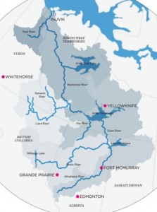
Mackenzie River – This is Canada’s longest river and most extensive freshwater drainage basin. It contains three of Canada’s largest freshwater lakes, Great Slave, Great Bear and Lake Athabasca. Its headwaters originate in glaciers in Alberta and British Columbia. From there the river flows north into the Arctic Ocean. Another unique characteristic of the Mackenzie is permafrost. The impact of warming which is forecasted to be greater in the Arctic than at the equator, therefore, will enormously impact the Mackenzie. Glacial melt will be less a problem than the disappearance of the permafrost and the accelerated release of methane hydrates trapped in the frozen ground. For the native North Americans, the communities found along it many tributaries and lakes, and the wildlife, the changes here will be more significant than anywhere else on the continent.
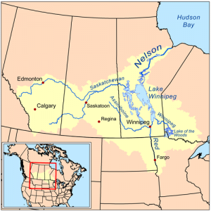
Saskatchewan-Nelson River System – One of the most overlooked watersheds of North America, the Saskatchewan-Nelson flows from the Rocky Mountains in the west to Hudson’s Bay. It includes the North and South Saskatchewan, Bow, Red, Assiniboine and Nelson Rivers as well as Lake of the Woods in Ontario, Lake Winnipeg, Manitoba, Winnipegosis and Cedar. Edmonton, Calgary, Saskatoon, Regina, Winnipeg and Fargo are among the major cities to be found in the watershed. The river basin is Canada’s granary for the world producing wheat, canola, corn and soy bean for domestic consumption and export.
Climate change is posing a great threat to the integrity of this watershed. The melting of its glaciated headwaters has been apparent since the mid-2oth century. Just one of those glaciers, the Athabasca has retreated miles from the famous Ice Fields highway that runs between Banff and Jasper in Alberta. I remember visiting the Athabasca in 1973 with the foot of the glacier meters from the highway. Today it is kilometers away. The net decline amounts to 16 million cubic meters of water annually, and along with declining winter snows, is contributing to a 40% loss in river flow over the last 75 years for the North Saskatchewan.
Higher evapo-transpiration rates are predicted on Canada’s Prairies over the next 50 years with average temperatures expected to rise by as much as 3 to 5 Celsius (5.7 to 9 Fahrenheit). For every 1 Celsius (1.8 Fahrenheit) increase, stream flow on the Saskatchewan is expected to decline by up to 15%. And this is happening despite increases in precipitation on average throughout the watershed.
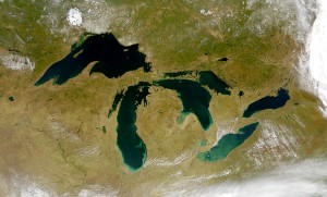
Great Lakes-St. Lawrence River System – It is impossible to ignore this dominating feature of North America (see satellite image below). The Great Lakes basin drains an area greater than 1 million square kilometers (620,000 square miles) and includes the largest freshwater source in the world. Superior, Michigan, Huron, Erie, and Ontario are the predominant lakes which flow through the St. Lawrence River to the North Atlantic. The largest tributary in the system is the Ottawa, entering the St. Lawrence near Montreal, one of the many cities located within the watershed. Duluth and Thunder Bay on Lake Superior, Detroit, Cleveland and Buffalo on Lake Erie, Toronto, Kingston and Rochester on Lake Ontario, and Ottawa-Hull, Montreal and Quebec City are the major cities of the watershed which is home to over 40 million.
So how is climate change impacting this watershed? Although the Great Lakes represent a post-Ice Age legacy of a much larger lake that existed until 13,350 years ago, the water contained within them comes from annual precipitation. Any change to the annual accumulation of snow during the winter supplemented by spring, summer and fall rain is, therefore, critical to maintaining lake water levels. And those lake water levels are needed to ensure a freshwater supply to the population that inhabits the watershed. In addition, the Lakes and St. Lawrence River is a transportation corridor for shipping from the Atlantic Ocean to Duluth, Minnesota.
The first challenge will be what rising temperatures do to the evapo-transpiration rate. It is expected that as temperatures rise the Lakes will experience lower water levels. Shorter winters will mean less snow pack to restore lake levels in the spring. Not only will atmospheric temperatures rise, so will the temperature in the lake water. That warming will change the species of plants and animals in the Lakes.
Average precipitation may increase on the Prairies but climate change is expected to lower the amount of rain and snow over the region. This will impact water levels further and the natural flushing of the lakes. That means a greater likelihood of freshwater contamination and lower habitat oxygenation, impacting shoreline integrity and wetlands.
With lower lake levels shipping will be impacted with ports and harbors forced to do dredging to maintain lake access.
In the conclusion of our look at the rivers of North America our focus will move south. So stay tuned for the next installment.


