August 26, 2018 – In this month’s issue of Mechanics Research Communications, engineers from the University of Melbourne describe an algorithm they have developed to predict where a landslide is going to occur about two weeks in advance. Robin Batterham, a professor of engineering at the University and one of the prime developers of this new software, describes in an article appearing on the Futurity website its importance as a prediction tool. He states, “we want as much lead time as possible to try and stop the landslide if we can, and otherwise to evacuate communities, remove equipment, and prepare for recovery.” He goes on to describe how the software will predict when a landfill wall might collapse, or building foundation crack, a dam break, or a mudslide occur.
The software incorporates:
- the collective knowledge engineers and applied mathematicians related to the micromechanics of a variety of media including individual sand grains, and their surface movement characteristics on slopes.
- analysis of kinematics, referring to a branch of mechanics that studies objects and their motion characteristics in isolation from any external forces and looking at these objects and their interactions in complex networks.
- input from radar data studying slopes in real time noting trends and tendencies.
- a prediction algorithm that quantifies the probability of a landslide within a specified time limit up to two weeks in advance.

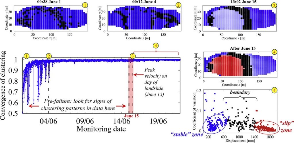
Antoinette Tordesillas, Professor of Applied Mathematics, and lead author in the journal report describes just how tricky and subtle landslide warning signs can be. “Identifying them requires fundamental knowledge of failure at the microstructure level—the movement of individual grains of earth…Of course, we cannot possibly see the movement of individual grains in a landslide or earthquake that stretches for kilometers, but if we can identify the properties that characterize failure in the small-scale, we can shed light on how failure evolves in time, no matter the size of the area we are observing.” The software shows that the patterns of movement detected over time begin with disorder but as a point of failure gets closer become more ordered making the prediction of a slide possible.
Mining companies traditionally use radar data on unstable slopes to detect surface movements. The radar scans are done every six minutes leading to a mountain of data to interpret. For humans the amount of data produced makes it almost impossible to find the pattern that would predict a landslide. But the software can break down movement into individual dots noting when two or more link to form a network. The linkages in networking of these dots provide the pattern of slope behaviour that the software analyzes to make its predictions.
Needless to say, this is software that will save thousands of lives in the face of extreme weather events caused by climate change. Just think if the software had been available in Laos to warn the nearly 12,000 people affected by a catastrophic hydroelectric dam collapse in July of this year. Over 6,000 Laotians were displaced from their homes, and 130 lives were lost according to a CNN report.


