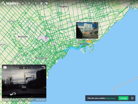
January 30, 2019 – Meet Mapillary, a Malmo, Sweden-based company that is learning to create street-level navigation through crowdsourcing. The maps it creates represent the collected data from thousands of volunteers who send in imagery and location to the company which then renders it into accurate, up-to-date 3D images for navigation.
Mapillary can be integrated into almost any tool, application or website. It connects to the most popular geographic information systems (GIS) through integration with ArcGIS, OpenStreetMap, and HERE Map Creator. Mapillary co-founder, Jan Erik Solem, a mathematician by training, describes the difference between his product and Google Maps and Street View, as a mapping system that doesn’t need a camera-equipped vehicle out on the road constantly refreshing the centralized image database.
Instead, Mapillary involves individuals, institutions, and companies to contribute images that can be immediately incorporated into online maps. For navigation systems, the difference between a Google Streetview and Mapillary would be immediately notable when road conditions suddenly change, a sudden storm, a flash flood, powerlines down or a fallen tree, all likely to make a street impassable.
The collaborative model is Mapillary’s unique value proposition. The question is can the company sell it to automotive developers building navigations systems for their models, and eventually for autonomous vehicles. The ability to produce maps and digital images of hazards happening in real-time will make self-driving vehicles more reliable.
To publish street-level imagery and accurate maps, the application imports and renders the data it collects using computer vision and machine learning technologies. As more images get shared the maps automatically update creating real-time, street-level views. Images and data can be extracted by time and by objects within the images which are then visually displayed on maps.
Currently, Mapillary is adding hundreds of thousands of images daily from volunteer contributors all over the world helping it to build a global cloud map of all major roads on Earth.
The application automatically detects 65 classes of objects including:
| Curb Fence Guard rail Barrier (other) Lane separator Wall Bike lane Crosswalk (basic) Curb cut Parking Pedestrian area Rail track Road Road shoulder Service lane Sidewalk Traffic island Bridge Building Garage Tunnel Person |
Lane marking (dashed) Lane marking (solid) Crosswalk (zebra) Lane marking (other) Lane marking (stop line) Lane marking (text) Sky Snow Lawn Trees Water Banner Bench Bike rack Billboard Catch basin Fire hydrant Junction box Mailbox Manhole Parking meter Pothole |
Streetlight Pole (generic) Traffic sign frame Utility pole Traffic cone Traffic light Traffic sign Construction sign Trash can Bicycle Boat Bus Car Caravan Motorcycle Train Vehicle (other) Trailer Truck Wheeled slow vehicle Wire group |
The computer vision visualizes everything and places these objects in real-time on maps.
Besides all these objects the application detects and differentiates among 1,500 types of traffic signs from 100 countries.
To become a Mapillary contributor you just have to sign up and start sending them pictures of your streets. The company sponsors mapathons and Maptime events to spread the word. Companies, utilities, and governments can open a Mapillary account and begin building cloud-based maps.


