September 26, 2018 – In partnership with the Global Covenant of Mayors for Climate & Energy, Google has created the Environmental Insights Explorer (EIE), a site that estimates carbon emissions from data gathered from Google Earth, Google Maps, and other proprietary data sources.
Creating reliable data on carbon emissions is the goal of this new tool. Analyzing Google gathered data allows EIE to identify hot spots where interventions can work, and where they are working effectively.
The data sources include location history, building outlines and types, street-view and overhead imagery, and other information gathered from Google’s many data aggregating tools and applications.
EIE does a greenhouse gas (GHG) accounting by inventorying source of emission sites, energy consumed, types of fuels being burned, and then uses the information to create a calculation which city planners can use to prioritize where mitigation strategies and reductions are needed.
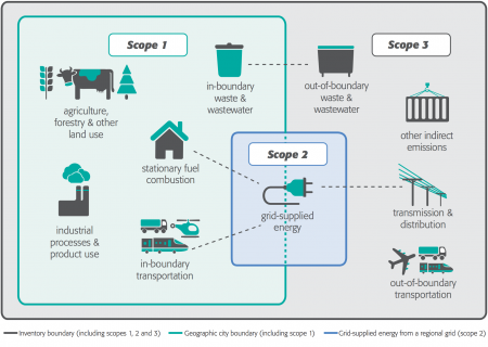
EIE does its calculations based on default administrative city boundaries. It accounts for seven GHGs: carbon dioxide (CO2), methane (CH4), nitrous oxide (N2O), hydrofluorocarbons (HFCs), perfluorocarbons (PFCs), sulfur hexafluoride (SF6) and nitrogen trifluoride (NF3).
Currently, the tool is using data collected from 2017 to build a city emissions profile with the principal focus on:
- fuel combustion in commercial and residential buildings
- grid-supplied electricity to the above
- in and out-boundary road vehicles, and boats including emissions from trips starting within city boundaries and finishing outside, or starting outside and finishing within.
Other emission sources including air transport, waste management, agriculture, and forestry are currently not being calculated by the EIE. Protocols employed include the Global Protocol for Community-Scale Greenhouse Gas Emission Inventories (GPC).
EIE uses Google Earth’s analysis platform along with NASA’s Earth Exchange Global Daily Downscaled Projections datasets for doing climate projections.
Google’s partner in the development of this tool, the Global Covenant of Mayors for Climate & Energy is an association of 9,149 cities representing over 780 million people and more than 10% of the world’s population.


