September 5, 2017 – Can there be a Category 6 hurricane? Not based on the current measuring standard. Category 5 is top of the charts for the Saffir-Simpson scale. But maybe it shouldn’t be particularly if we see Irma turn out to be another beyond the scale storm. Then it may be time for a Category 6.
Hurricanes Aren’t the Only Weather Phenomena Approaching Extremes
If you look at weather maps today in places like Australia and India you’ll note a new isotherm (the line that marks the delineator between different ranges of temperature).
Australia in the last few years added a 50 Celsius (122 Fahrenheit) isotherm. That’s because the interior of the continent has seen temperatures exceed that amount for extended periods for the first time in recorded history.
India, Iran, Pakistan, Saudi Arabia, the United Arab Emirates and other countries spanning the tropics or desert zones of the planet are also adding a 50 Celsius isotherm.
A friend of mine visiting Greece this summer told me that temperatures regularly exceeded 40 Celsius. Greece wasn’t alone. Much of Southern Europe and the Mediterranean littoral experienced unprecedented heat waves.
So those people who chart the weather on maps are having to add a new upper scale when dealing with temperature.
It’s Happening with Hurricanes Too
Hurricanes appear to be getting more intense. The prevailing science states that these storms when moving over large swaths of warm ocean water can intensify dramatically in a very short period of time. That’s what we witnessed with Harvey, a storm that jumped from a Category 3 to 5 in a very short period of time.
If you are unfamiliar with the current Saffir-Simpson classification scheme for these monster storms, it is as follows:
| Category | Wind speed | Damage |
|---|---|---|
| 1 | 119 to 153 kms. or 74 to 95 miles per hour | Winds produce some damage. Well-constructed frame homes have damage to roof, shingles, vinyl siding and gutters. Large branches of trees snap and shallowly rooted trees may be toppled. Extensive damage to power lines and poles likely result in power outages lasting one or more days. |
| 2 | 154 to 177 kms. or 96 to 110 miles per hour | Winds cause extensive damage: Well-constructed frame homes sustain major roof and siding damage. Many shallowly rooted trees are snapped or uprooted and block numerous roads. Near-total power loss occurs with outages that last from several days to weeks. |
| 3 | 178 to 208 kms. or 111 to 129 miles per hour | Devastating damage occurs: Well-constructed frame homes incur major damage including removal of roof decking and gable ends. Many trees are snapped or uprooted, blocking numerous roads. Electricity and water become unavailable for several days to weeks. |
| 4 | 209 to 251 kms. or 130 to 156 miles per hour | Catastrophic damage occurs: Well-constructed frame homes sustain severe damage with loss of most of the roof structure and exterior walls. Most trees are snapped or uprooted and power poles are downed. Fallen trees and power lines isolate residential areas. Power outages last weeks to possibly months. Most of the area impacted becomes uninhabitable for weeks to months. |
| 5 | 252 kilometers or 157 miles plus per hour | Catastrophic damage occurs: A high percentage of homes are destroyed, with total roof failure and wall collapse. Fallen trees and power poles \isolate residential areas. Power outages last for weeks to months. Most areas remain uninhabitable for weeks to months. |
Note that the Saffir-Simpson scale doesn’t account for coastal storm surges, rainfall, and flooding. Harvey’s winds may have hit a Category 5 just before landfall but the real damage from it appears to be the coastal storm surge and the enormous amount of precipitation unleashed leading to extensive lowland flooding.
Harvey’s winds may have briefly hit Category 5 just before landfall but the real damage from it appears to be the storm surge and the subsequent enormous amounts of precipitation unleashed leading to extensive lowland flooding.
Irma is Coming

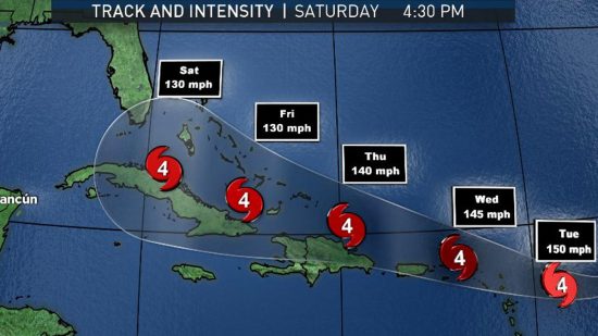
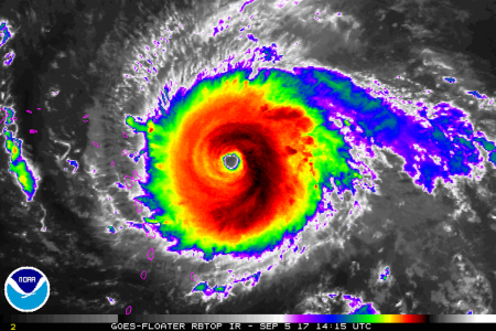
Irma (see the projected track on the map above) is next in the chain of storms this year. Already its winds exceed the low end of Category 5 at 280 kilometers (175 miles) per hour. And Irma isn’t weakening as the storm moves westward towards the Leeward Islands, Bahamas, Puerto Rico, Hispaniola, Cuba, and likely Florida. Eastsern Caribbean sea temperatures are above normal and the warm water is fuel to Irma. It is likely that the hurricane will see wind speeds exceed 300 kilometers (186 miles) per hour. Irma may join a rogues gallery of killer storms. On wind speeds alone the top 5 of all time include:
Irma could end up joining the rogues’ gallery of killer storms. The top 5 all time for wind speed include:
- Hurricane Patricia which struck in 2015 with wind speeds of 345 kilometers (245 miles) per hour.
- Typhoon Haiyan in 2013 with wind speeds of 315 kilometers (196 miles) per hour.
- Hurricane Allen in 1980 reaching wind speeds of 305 kilometers (190 miles) per hour.
- Typhoon Tip in 1979 hitting wind speeds of 305 kilometers (190 miles) per hour.
- Hurricane Wilma in 2005 with wind speeds of 295 kilometers (183 miles) per hour.
Note Hurricane Katrina doesn’t make it to this list as a Category 3 storm. Yet Katrina was the most devastating hurricane to strike the United States coast before Harvey, displacing millions and killing more than 1,800.
Nor does the Great Hurricane that struck Galveston on September 8, 1900 before storms were given names. Galveston witnessed a storm surge that wiped out the city and killed 12,000.
Nor does the San Felipe-Okeechobee Hurricane of 1928 that struck Palm Beach, Florida and caused a storm surge on inland Lake Okeechobee that killed 1,800.
And then there is Sandy in 20102 which flooded the New Jersey and Long Island coasts as well as Lower Manhattan, bringing New York City to a grinding stop.
So hurricanes aren’t just to be feared for high-speed winds. They hatch all kinds of deadly weather phenomena. And the future prognosis in light of global warming and climate change indicates greater intensity as well as altered tracking behavior. Climatologists point out that Harvey may be a symptom of a new phenomenon. The storm appeared to stop dead after landfall. This behaviour fueled intense rainfall as the storm continued to draw on moisture from the warm Gulf of Mexico. And many climatologists believe that a warming atmosphere will lead to more of these types of fronts blocking the progress of the normal hurricane path, westward followed by a turn to the northeast. Harvey eventually moved northeast but the stalling over the Texas coast and hinterland proved to be utterly devastating.
Mny climatologists studying hurricanes believe that a warming atmosphere will lead to more storms slowing down and deviating from the normal path, westward followed by a turn to the northeast. Harvey eventually followed that pattern but not before a long pause that proved devastating to Houston and coastal Texas.


