
Please welcome Kateryna Sergieieva, a first-time contributor to the 21st Century Tech Blog. Kateryna is a senior scientist at EOSDA, a geospatial data provider of high-resolution imagery. She has a doctorate in information technology and has been working in remote sensing for 15 years. She is responsible for developing technologies for satellite monitoring and surface feature change detection and has authored more than 60 scientific papers.
Kateryna describes how remote monitoring using satellites is revolutionizing how farmers combat crop infestations and diseases through the analysis of high-resolution images and advanced data analytics. I’ll let her explain the rest. As always your comments are welcomed.
Pest and disease management is crucial in agriculture, protecting crops from seen and unseen threats that devastate harvests and livelihoods. Traditionally, farmers have relied on their experience and natural remedies. Today, geospatial data availability and analytics have transformed agricultural practices using tools like satellite imagery, drones, and a form of artificial intelligence called machine learning to detect pest and disease crop infestations allowing for early and precise interventions. Tools include smart sensors deployed to monitor soil and plant health in real time and data analytics to offer insights into effective pest control. Biotechnological advances using genetic modifications are producing disease-resistant crops and reducing the need for chemical pesticides.
Although satellites may seem far away and incapable of spotting something as small as an insect, other pests and early stages of disease, they are proving to be quite effective in these tasks.
Two technological advances, one an Earth observation instrument and the second, EOS Data Analytics when combined represent the current state-of-the-art to help farms monitor different crop and soil parameters from advanced remote satellite imaging and data collection.
Traditions vs. Technology
Traditional methods while rooted in time-honoured wisdom and experience face many limitations and challenges in today’s complex agricultural landscape.
One of the primary issues is the unpredictability of pest and disease outbreaks. Growers often rely on manual inspections and past experiences, which can be subjective and inconsistent. This reactive approach means that infestations are often identified only after they have caused damage that is already impossible to avert completely.
Another limitation is the reliance on chemical inputs. Although they can be beneficial in the short term, these substances cause detrimental effects on the environment, including soil degradation, water contamination, and harm to beneficial insects and wildlife.
Another issue to consider is pest resistance to chemical treatments over time, which means even stronger hence more harmful analogues need to be applied with negative environmental consequences.
The labour-intensive nature of manual monitoring and intervention requires substantial time and effort which can be particularly burdensome for small-scale farm operations. Furthermore, these methods often lack precision and lead to the over-application or under-application of treatments.
Climate change also doesn’t work in our favour here. Warmer temperatures and changing precipitation patterns create better conditions for pests and diseases to thrive often in areas where previously they were of no concern.
Given these limitations, the need for innovative solutions becomes clear. Precision agriculture tools such as satellite imagery provide farms with real-time data and early warnings of potential threats. Machine learning and data analytics enable more accurate predictions and tailored interventions reducing reliance on chemicals.
Integrated Pest and Disease Management Practices
Satellite technology with its far-reaching eyes offers growers a way to manage fields in ways that no other methods can. By analyzing high-resolution images farmers can see early indications of changes in vegetation patterns, colour and growth no matter the weather conditions and distance. The application of predictive analytics along with these images gives farmers the tools needed to make smart decisions.
Early Detection and Monitoring
Satellites identify signs of disease or pest outbreaks utilizing vegetation indices like NDVI, NDMI, ReCl, and NDRE. These track the state of health of plants at different stages of growth.
EOSDA Crop Monitoring from EOS Data Analytics leverages these indices to provide real-time insights into crop health. A crop monitoring system can assign scouting tasks to farmers based on satellite data. The system can confirm crop damage, identify specific diseases (biotic or abiotic), and communicate detailed descriptions to agronomists and farmers for timely interventions.
Using GPS coordinates a crop monitoring system can precisely target an area for intervention rather than address the problem as field-wide.
Predictive Analytics
The predictive analytics in the Disease Risk feature of EOSDA Crop Monitoring spots nascent pest infestations and diseases before they become a larger problem. The analytics can assess risk levels across different zones allowing farmers to prioritize and address the most endangered crops.
A Data Manager feature provides data analysis comparisons to make accurate yield assessments during harvesting. It produces maps that highlight areas of varying productivity and can help identify and manage low-productivity plots resulting from biotic pathogens.
EOSDA Crop Monitoring also offers data on soil moisture levels, temperature extremes, and weather conditions to ensure that farmers can manage both biotic and abiotic factors to safeguard their yields.
Resource Optimization
Using real-time remote sensing data gives farmers the means to make smarter decisions when using pesticides to target affected crops. Detailed satellite imagery can identify exactly where these infestations are happening allowing for precision rather than blanket application of chemicals and pesticides. Cutting down on chemical and pesticide use lowers costs and reduces environmental risk.
Satellite tracking of soil health and moisture levels means farmers can use less of both more effectively ensuring these resources get applied where needed most to promote sustainable farming practices.
Farm Technology Trends Now and in the Future
Expect satellite technology to continue to play a critical role in precision agriculture. Biotechnological innovation is also paving the way for safer pest control methods. A good example is the Wolbachia project which breeds mosquitoes that can’t transmit diseases. We are already seeing the use of biological weather stations to identify and track pest species and diseases providing valuable data to predict and manage outbreaks. At the same as in the Wolbachia project, we are using the science of genetic modification to deal with these invasive threats.
The Internet of Things is being deployed today to support agriculture. It is revolutionizing pest monitoring using millions of sensors to collect environmental, optical, and sound data. This real-time information enables early detection and facilitates targeted interventions.
Big Data analytics combine information from various sources including pest biology, weather patterns, and control activities to optimize strategies and provide holistic insights into pest dynamics. AI is enhancing analytics tools by adding the capacity to offer recommendations or even apply autonomous decision-making to a perceived threat.
Robotics and drones are bringing precision to pest management enabling their detection and control regardless of location. Drones and field robots can precisely target the use of pesticides or biological agents minimizing chemical use and environmental harm, and they are only getting more sophisticated and smarter.
Augmented reality and virtual reality are playing a part as well. Virtual reality can be used to train farmers. Augmented reality can give farmers a heads-up view of all the data and imaging information to help make decisions about where the problems lie and best practice solutions.
All of these advancements are creating more sustainable, efficient, and resilient agricultural practices that can meet the challenges of pest and disease management here in the 21st century.
Related Posts
 Science Without The Humanities In College Is Poor Education
 Futurists Want Children to Learn AI Calling it a Must
 Has Climate Change Made Commercial Flight More Problematic?
 Trump’s Pitch for Greenland and Canada Is Not Unprecedented When You Look At Colonialism
 What Happens to Navigation When GPS and a Map Are Unavailable
 Doctor Activism On Climate Sparks Canadian Election Letter-Writing Campaign
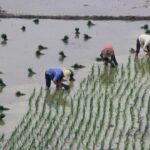 Rice Can Be Modified To Emit 70 to 90% Less Methane
 The Future of Authentication: AI-Powered ID Reader Scanners vs. Traditional Methods