Welcome Peter (Petro) Kogut to the 21st Century Tech Blog. Peter has a PhD in Physics and Mathematics and is an author of numerous scientific publications. His specific focus is on satellite imagery processing.
From the beginning of the satellite era, remote sensing was seen as a principal use of this emerging technology. In the 1970s, America’s Landsat satellites provided the first comprehensive survey of the planet using digital image processing. Today, the European Space Agency’s Sentinel satellites provide high-resolution imaging for studying the environment and climate change.
In this, his first contribution to the blog, Peter writes about how satellite imaging systems are being used to track wildlife in the face of habitat loss, human encroachment, and climate change.
The ability to track wildlife behaviour from outer space sounds like science fiction, but it is quickly becoming one of the most valuable tools for conservationists. As species face mounting threats from habitat loss, climate change, and human activity, the ability to monitor species and their movements and behaviors is more critical than ever. Satellite imagery captures vast, remote areas without disturbance, opening up possibilities to understand and protect wildlife in ways never imagined.
Protecting Wildlife with Satellite Data
Conservationists using satellite imagery can observe habitats from a distance without disturbing the wildlife. As ecosystems shift under the pressure of climate change, deforestation, urban development, and poaching, the need for reliable, real-time data is important. Fortunately, existing Earth observation satellites, including the Sentinel-2 mission, are proving invaluable.
Sentinel-2 is part of the European Space Agency’s(ESA) Copernicus Program. It delivers high-resolution optical imagery of the Earth’s surface in remarkable detail. Its frequent revisit time and broad spatial coverage make it especially valuable for monitoring dynamic environments like wetlands, savannas, forests, and coastal areas where wildlife activity is often concentrated. Sentinel-2 can detect changes in vegetation health, water availability, land degradation, and other key environmental indicators. When scientists view Sentinel-2 imagery, they can study changes to the Earth, identifying habitat loss, mapping seasonal patterns, and predicting future shifts that can impact wildlife.
For example, scientists can see how the migration routes of elephants change because of drought, or how reindeer respond to thawing permafrost. The multi-spectral sensors aboard Sentinel-2 can monitor the health of coral reefs that support species like sea turtles and reef fish. It can detect coral bleaching and sediment from land runoff. In grassland and savanna systems, satellite images help to map vegetation cover and track changes over time, information that is critical to conservation and the protection of grazers such as antelopes and zebras.
Beyond habitat analysis, satellites play a crucial role in identifying the human-driven threats to wildlife. Sentinel data reveals patterns of illegal logging in protected areas, the expansion of agricultural fields into conservation zones, and even the construction of roads that fragment habitats and facilitate poaching. These visual cues are often the first signs of encroachment and give authorities evidence to intervene.
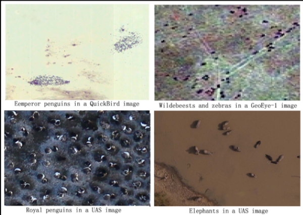
Moreover, satellite imagery supports long-term population monitoring. In Antarctica, Emperor Penguin colonies can be tracked by spotting guano stains on the ice, which can be seen from space, as captured in the upper left satellite image that appears at the beginning of this posting.
In the open landscapes of Africa and Asia, herds of wildebeest or camels can be monitored through time-lapse analyses of movement patterns. This digital data can be cross-referenced with information such as climate trends or wildfire activity to better understand how external stressors influence animal distribution and behaviour.
Sentinel-2 Images on EOSDA LandViewer
Accessing Sentinel-2 satellite imagery for wildlife monitoring has never been easier, thanks to EOSDA LandViewer, a powerful and intuitive platform designed to explore and use Earth observation data. With a few clicks, a user can visualize environmental changes, track animal habitats, and assess land conditions across the most remote ecosystems. Whether monitoring seasonal shifts in savannas that affect zebra migrations or watching coastal changes that impact nesting sites of endangered sea turtles, the EOSDA LandViewer puts the insights of space-based observation at your fingertips.
To get started, users just need to select the area of interest and choose the Sentinel-2 data source. The platform allows for applying various band combinations and spectral indices, helping to highlight vegetation health, water bodies, and land cover, all crucial factors in understanding and protecting wildlife. Experts can also compare images from different periods to detect subtle habitat changes or disturbances caused by human activity.
EOSDA LandViewer’s role in animal monitoring goes beyond just viewing images. Conservationists use its time-series analysis tools to uncover long-term environmental trends influencing species distribution. With historical data, dynamic visualization features like time-lapse animations, and the ability to download Sentinel-2 data for deeper GIS analysis, the platform supports decision-making across a wide range of wildlife protection efforts, from field research to policymaking. Whether it’s spotting signs of habitat degradation or planning conservation zones, LandViewer ensures that satellite data is not just accessible, but actionable.
Other Technologies in Animal Monitoring
Alongside satellite imagery, several other technologies are used to track wildlife. GPS collars and tags can monitor individual animals in real-time and understand migration pathways, territorial ranges, and other behaviours. Camera traps, deployed in the field, capture still and video images of wildlife without human intrusion to allow researchers to quantify the presence, abundance, and activity of different species. Increasingly, drones are being deployed to do low-altitude monitoring, where satellites cannot provide detailed imagery. Acoustic sensors are also being used to record animal calls or movement sounds, particularly useful for nighttime tracking of species.
All of these other technologies complement satellite data to add ground-level details that satellites alone cannot provide. The combination delivers a powerful, multi-layered view of the past and current status of Earth’s wildlife populations. As environmental pressures continue to grow from human activity and climate change, this integration of space-based and ground-based observation tools offers humanity the best path forward to preserve the planet’s biodiversity in the 21st century.


