December 15, 2014 – I am asked this question a lot. My answer is simple. Weather is what is happening today and being forecasted over the next few days. It is the daily phenomena of local atmospheric churning. On any given day the weather we experience has little to do with the overall dynamics of Earth’s atmosphere. But sometimes weather reflects a discernible change in atmospheric dynamics.
Climate change isn’t today’s or tomorrow’s weather. Climate change is the analysis of the dynamic changes in our physical world and its surroundings. Climate change looks at our Sun’s energy output, at Earth’s axial wobble, at atmospheric composition, at ocean currents and thermodynamics, at changes to planetary biomass. Climate change models all of these variables and creates simulations that cover years and decades, not days.
Sometimes even the best scientists confuse us all when they point to a hurricane and say “this is evidence of climate change.” A single hurricane is not! A trend over decades that tracks changes to hurricane frequency and intensity may very well be!
In the December 2014 issue of Scientific American, an article entitled “The Jet Stream is Getting Weird“ explains the winter of 2013-14 polar vortex as a weird change in the pattern and flow of the polar jet stream.
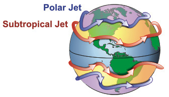
If you are not familiar with the jet stream it is an ever present wind that circles our globe some 9 to 14 kilometers (approximately 5.6 to 8.7 miles) above the surface of the Earth. There are two of these in each of the northern and southern hemisphere. One is located at high latitudes and the second in the mid-to-low latitudes.
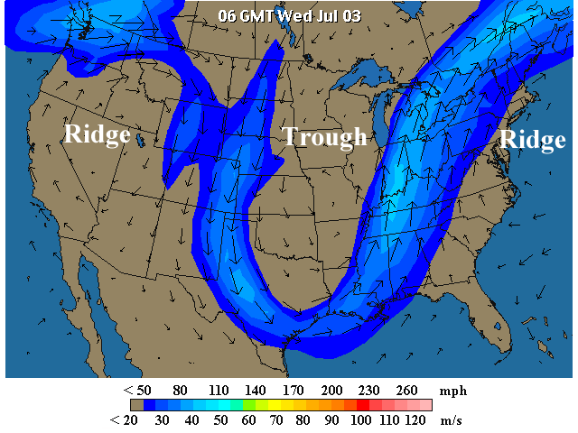
Our weather experiences are largely the product of systems that follow the path of these jet streams. Just look at any weather map (see below) and where you see ridges of high pressure and troughs of low pressure you can impose on that same map the jet stream (seen in blue) in lock step.
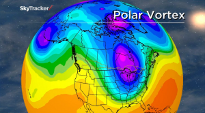
The one closer to the poles is the subject of the Scientific American article. It describes a jet stream contorted beyond anything previously measured leading to “outlandish weather.” The Polar Vortex of last winter that dropped temperatures in Eastern North America to the point that the Great Lakes almost froze in entirety, a very rare event, is blamed on a stalled jet stream that maintained a weird weather pattern for weeks on end.
Is a stalled contorted jet stream an indicator of climate change? It may very well be. That’s because big atmospheric forces influence it and the persistence of an altered pattern in its track could be symptomatic of our altering atmosphere. But it also may be a symptom of the cyclic nature of a number of variables such as solar intensity, axial wobble and phenomena such as the El Nino and La Nina events which occur every few years in the western Pacific Ocean and subsequently set off a chain reaction that impacts North America.
The Polar Vortex of last winter and the changing pattern of the jet stream were more than coincidence. The cause remains controversial. Was the melting of Arctic Ocean sea ice primarily responsible? Meteorologists have noted in numerous studies that Arctic amplification of the atmosphere in northern latitudes has been in evidence for the last 15 years. But there is no consensus as of yet that this is derived directly from the shrinking summer sea ice. That’s because the observed energy gained in the atmosphere from increased warmth over the open sections of the Arctic Ocean is not seen to be sufficient enough to drive the kind of changes observed in the wobbling of the jet stream. It could just be natural variability. After all North America and Central Asia have experienced long winter cold snaps in the past.
So this is where it gets hard to determine if what we saw last winter was weather or climate change. We need more data observed over a longer period to make the call.
